Oil Collected North of Dauphin Island Rapidly Disappears in Glass Jars

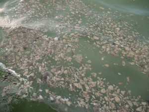
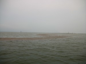
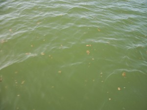
In my previous post, I showed pictures of LOTS OF OIL just off the Dauphin Island beaches (two of those pictures are included below). At that same time, I collected two samples of the oil and provided them to scientists. But before I gave them the samples some very strange things happened. The first sample included several clogs of oil and about a cup of seawater from an area of surface oil like the picture on the left. The second sample was gathered from an area of dense surface oil like the picture on the right. The oil collected in the second sample was very liquidy and contained very little seawater. I collected the samples around 5:45 P.M., August 4 (yesterday). By noon of the following day (today), dramatic changes had taken place in both samples. By noon, the water with the clogs of oil had turned clear, and the clogs of oil had either dissolved or evaporated and were no longer visible. By noon, there were just a few black granules at the bottom of the jar. In another strange development, also by noon, the oil in the second container had lost over half its volume (the glass jar which was filled to the brim was mostly empty). Both jars were closed with lids.

Surface oil in the Mississippi Sound, photographed August 4, 2010

Surface oil in the Mississippi Sound, photographed August 4, 2010

Oil with Dauphin Island bridge and houses in the background

Oil with Dauphin Island bridge and houses in the background, Dauphin Island west of Katrina Cut is behind the photographer, August 4, 2010.


Larger original photographs used in this and the previous post:

I am Really Mad – No More Oil – Open Your Eyes!

All the oil is gone right? Just listen to the national news. Time to lift the swim ban … it’s lifted … small children are now swimming on Dauphin Island. Area seafood … of course it’s safe? There’s just one big problem. The oil was still here last week when the no-more-oil PR campaign began, and right now the oil is still CLEARLY VISIBLE … RIGHT ON THE SURFACE … AS BAD AS EVER … IN THE MISSISSIPPI SOUND … WITHIN 100 YARDS OF DAUPHIN ISLAND.

Click photos to see higher resolution images. Permission is granted for anyone to use these photos.

Surface oil in the Mississippi Sound, photographed August 4, 2010

Surface oil in the Mississippi Sound, photographed August 4, 2010

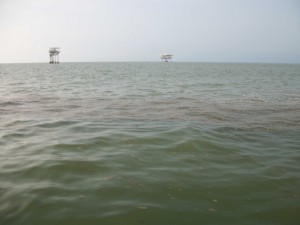
Do you see oil?

Yes, that’s oil from Deepwater Horizon catastrophe right on the surface of the Mississippi Sound next to Dauphin Island, photographed August 4, 2010

Oil with Dauphin Island bridge and houses in the background

Oil with Dauphin Island bridge and houses in the background photographed August 4, 2010.

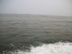
"This isn't the oil you're looking for." "This isn't the oil we're looking for." "Move along." "Move along."

Remember Star Wars: “This isn’t the oil you’re looking for.” “This isn’t the oil we’re looking for.” “Move along.” “Move along.” Time to open our eyes! Photographed August 4, 2010.

Please share this post and these pictures with others, thanks much!


Larger original photographs for above photos:

Nobody Knows But Everyone Can Act

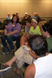
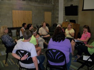
Small groups focused on specific topics and discussed experiences, ideas, and actions at the Future of the Gulf - Community Brainstorm

Small groups focused on specific topics and discussed experiences, ideas, and actions at the Future of the Gulf - Community Brainstorm, photographed July 21, 2010

With the tropics heating up and the approach of Tropical Storm Bonnie, various differences between the landfall of a hurricane and the waterfall of an oil spill come to mind. One major difference is our wealth of understanding about hurricane impact and damage as compared to our lack of understanding about this oil spill. How long will the effects of the oil remain in the gulf water? Nobody knows. How will the eco-system be changed as a result of the oil eruption? Nobody knows. With so many fishing areas closed now, is the toxicity of the gulf food chain going to get worse or better over the course of years? Nobody knows. What will become of the dispersants as they are released in the atmosphere, surface water, and deep water? Nobody knows. How long will tourism be affected? Nobody knows. How will the reputation of gulf seafood be affected over the long term? Nobody knows. What will be long-term physical and psychological effects on the people who live in coastal areas? Nobody knows.

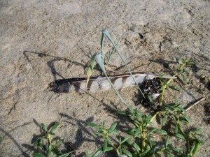
With so many unknowns, some signs are definitely unsettling. Yesterday, I saw an oiled osprey feather on the beach, there were miles of somewhat sparse oil floating in the Mississippi Sound, and much of the beaches of Katrina Key (Dauphin Island west of Katrina Cut) have still not been cleaned up after three weeks. The wildlife is definitely stressed and there are far fewer shore birds on the Island. Today, I saw three freshly killed sea gulls within a mile of the Dauphin Island bridge and in the early morning I could smell a diesel-like smell (probably from dispersants) in the air all over Dauphin Island.

On the hopeful side of all this, many people are keeping informed, sharing ideas, and doing things to make a difference. Ask yourself, what are my action items? Think things out with friends. Network. Pray. Make a list. Ask yourself, what do I need to look up or investigate? What can I do to build up my community or protect the environment? What can I do today? Each person’s actions can make a difference.

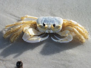
A sand crab too stressed to flee upon my approach

A sand crab near Katrina Cut too stressed to flee upon my approach, photographed July 22, 2010.

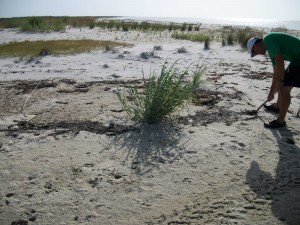
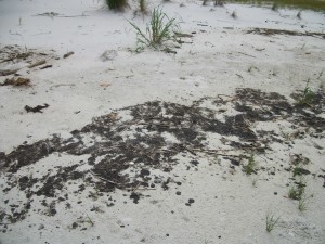
Joe Denton examines oil not cleaned from Dauphin Island for three weeks

Joe Denton examines oil not cleaned from Dauphin Island for three weeks, photographed July 22, 2010

An oiled osprey feather along the beach near Katrina Cut on Dauphin Island

An oiled osprey feather along the beach near Katrina Cut on Dauphin Island, photographed July 22, 2010

Surface oil in the Mississippi Sound north of the west end of Dauphin Island

Surface oil in the Mississippi Sound north of the west end of Dauphin Island, photographed July 22, 2010

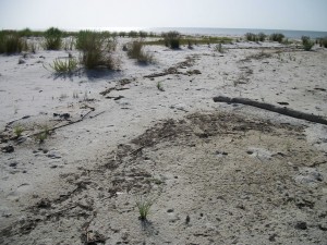
More oil not cleaned up for three weeks on Dauphin Island west of Katrina Cut

More oil not cleaned up for three weeks on Dauphin Island west of Katrina Cut, photographed July 22, 2010.

An animated small group discussion during the Future of the Gulf - Community Brainstorm

An animated small group discussion during the Future of the Gulf - Community Brainstorm, photographed July 21, 2010

Lest We Forget

Oil on Dauphin Island

Weeks have gone by and plenty of oil west of Katrina Cut on Dauphin Island still needs to be cleaned up, photographed July 16, 2010.

Earlier this year, Haiti was devastated by an earthquake. Over 200,000 people died. Despite the scope of this catastrophe, I hardly think of this anymore. It’s hardly visible to me. I need to change that because Haiti must still have tremendous needs.

The same scenario is about to be played out with the oil spill here. Like the Alaskan communities still suffering from the Exxon Valdez disaster, our environmental, health, economic, and community needs may easily be forgotten. Yes, BP and the government have promised to do all they can. But what can we, the people, do to fill the many needs that will go unmet? What can we do, to see that this kind of event be prevented in the future? I believe that our contribution as regular people can be momentous.


Under the News tab above, please check out our new section for the Haiti Earthquake.


You are invited to a brainstorming meeting about continued community focus and action on the oil spill. We as a group or groups will share about opportunities, needs, experiences, and resources. We will also generate ideas and inspire one another to be more aware, more focused, and more able to make a difference in our coastal communities. Rachel Guillory of Oceana and Leo Denton will facilitate the meeting.

The Future of the Gulf Community Brainstorm will be Wedneday, July 21, 7:00 – 8:30 P.M. at the Shelby Center at the Dauphin Island Sealab at 101 Bienville Boulevard on Dauphin Island. See Facebook event too.


A message from Alabama Coastal Foundation and Mobile Baykeeper:

“We encourage those of you who can give of your time to join those already working to protect our shores.  We have now trained over 300 Volunteer Field Observers to monitor Alabama’s shoreline.  Some of these volunteers have already devoted more than a month of their time doing weekly monitoring, and we are in need of a fresh group of volunteers as we continue to monitor for effects from oil.  Our next Volunteer Field Observer training will take place on Thursday, July 22 from 3:00 – 4:30 pm with a second training from 6:00 – 7:30 pm.  All trainings take place at 5 N Jackson street in Downtown Mobile. Please register by emailing saveourgulf@mobilebaykeeper.org to reserve your space.  Please make sure to let us know which training you wish to attend.”